Cut & Fill Calculation Explained for BC Contractors, Engineers & Surveyors
How drone-based cut/fill calculation transforms earthwork verification for BC construction projects, providing ±3cm accuracy with complete audit trails.
Executive Summary
Earthwork is the backbone of construction projects across British Columbia—from highway expansions and municipal infrastructure to commercial developments and residential subdivisions. Yet inaccurate cut/fill calculations remain one of the most common sources of billing disputes, project delays, and cost overruns.
This guide explains how drone-based cut/fill calculation transforms earthwork verification, providing ±3cm accuracy with complete audit trails suitable for billing disputes or legal proceedings.
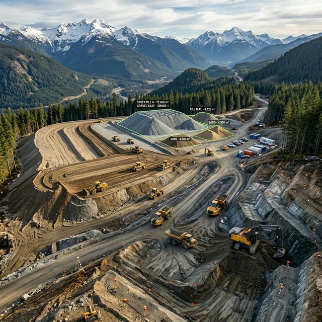
Modern drone photogrammetry captures thousands of images per survey, generating centimeter-accurate 3D models for precise earthwork volume calculations.
Traditional survey methods can take hours or days to complete, while drone surveys deliver the same accuracy in 15-20 minutes — with zero risk to survey personnel.
What Are Cut & Fill Calculations?
Cut/fill calculation is the process of determining earthwork volumes by comparing two surface conditions: existing ground (before construction) and design grade (after proposed work). The difference between these surfaces represents material that must be removed (cut) or added (fill) to achieve the desired elevation.
Why Cut/Fill Matters
For Contractors
Accurate cut/fill calculations determine how much material needs to be excavated and hauled away, equipment allocation, labor scheduling and crew sizing, and project timeline estimates.
For Owners/Developers
Cut/fill data enables budget accuracy, verification that contractor invoices match actual work performed, change order validation, and regulatory compliance with municipal grading permits.
For Engineers/Surveyors
Cut/fill analysis provides objective evidence supporting billing disputes, documentation required for municipal inspections, data for as-built drawings, and historical records for future projects.
Traditional Methods & Their Limitations
| Method | Time per Hectare | Accuracy | Safety Risk |
|---|---|---|---|
| Grid Method (Manual) | 4-8 hours | ±10cm | High — workers on site |
| GPS Receiver Tracing | 3-6 hours | ±8cm | High — walking active zones |
| Visual Estimation | Minutes | ±25-50% | Low |
| Drone Survey | 15-20 min | ±3cm | Zero — fully remote |
The Cut/Fill Calculation Workflow
Pre-Survey Planning & Site Preparation
Project requirements assessment, design grade acquisition (AutoCAD DXF/DWG, Civil 3D surfaces, Excel/CSV), flight authorization via DRATS system, and safety coordination with site teams.
Data Collection Flight Operations
DJI Matrice 300 RTK with P4R camera payload captures 300-500 images in 12-18 minutes. RTK GPS provides centimeter-level positioning connected to BC's CORS network. 6-8 Ground Control Points placed strategically.
Photogrammetric Processing & Analysis
Processed using Agisoft Metashape Pro or Pix4Dmapper. Millions of 3D points generated at 2cm × 2cm grid resolution. Cell-by-cell comparison: Cut/Fill Value = Existing Elevation − Design Elevation.
Reporting & Deliverables
PDF Cut/Fill Report (20-30 pages), CSV/Excel exports for billing integration, DXF/DWG files for CAD review, GeoTIFF DEMs, KML/KMZ overlays, web-accessible 3D models — all within 24 hours.
Example Scenarios in BC Construction
Example scenario with illustrative numbers, not a past client job.
Example: A Highway Widening Project
A highway expansion project involving 2km of road widening. Traditional methods resulted in payment disputes averaging $47,000/month.
Example: A Commercial Grading Dispute
A 15-hectare commercial development required extensive grading. Developer discovered mid-construction that earthwork quantities differed significantly from bid estimates.
A prompt drone survey and zone-by-zone breakdown provided objective evidence accepted by both parties. Settlement reached without litigation, avoiding legal fees.
Pricing & Service Packages
| Package | Price | Includes |
|---|---|---|
| Stockpile Volume | $250+ | Multi-stockpile measurements, Volume & inventory estimates, PDF reporting included, Spreadsheet exports available |
| Orthomosaic Mapping | $300+ | High-res aerial mapping, Full site overview imagery, Georeferenced map exports |
| Measurement & Mapping | $450+ | Volume calculations, Orthomosaic site mapping, Inventory reporting package, Material tracking support |
| Monthly Inventory | $375/mo+ | Scheduled monthly visits, Updated stockpile measurements, Updated site mapping, Inventory tracking reports |
✅ Key Takeaways
- Drone-based cut/fill calculations deliver ±3cm accuracy - better than traditional manual surveying (±10cm)
- Surveys complete in 15-20 minutes vs. hours or days for traditional methods
- Zero risk to personnel - fully remote data collection
- Fast turnaround with clear reporting and deliverables
- Typical ROI: 400-600% within first year of use
Frequently Asked Questions
How accurate are cut/fill calculations compared to traditional methods?
Our drone-based methodology achieves ±3cm vertical accuracy through RTK positioning and rigorous validation protocols—significantly better than the ±10cm typical of manual surveying. We've never had a client dispute our numbers because we provide irrefutable evidence.
Will drone flights interfere with my construction schedule?
Not at all. 15-20 minute flight times per site with pre-survey coordination means minimal disruption. Our compact drone footprint and quiet operation allow us to fly alongside normal activities.
How quickly will I receive my cut/fill report?
Turnaround depends on site conditions, weather, and survey complexity, but we provide a clear delivery timeline before the flight and keep the reporting process transparent from kickoff to handoff.
What equipment do you use for cut/fill surveys?
We use DJI Matrice 300 RTK drones with P4R cameras for high-resolution imagery. The RTK GPS connects to BC's CORS network for centimeter-level positioning, and we place 6-8 Ground Control Points strategically across each site.
Can you integrate with my existing CAD software?
Absolutely. We deliver DXF/DWG files compatible with AutoCAD, Civil 3D, and all major CAD platforms. We also provide CSV/Excel exports for easy integration into your billing systems.